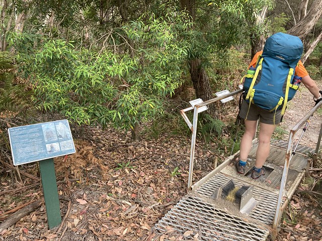
PLANNING FRAMEWORK
The Australian Adventure Activity Standard and associated Good Practice Guides cover weather. In the Australian Adventure Activity Standard v1.0 weather is covered as part of the Environment (5.1, p.8)
• weather and emerging weather variations
• severe weather and fire weather warnings
• bushfire and fire danger rating
Providers should identify and monitor weather and environmental conditions that might trigger modification,
evacuation or other relevant response.
The Core GPG Version 1.0 lists the documentation that must be available to activity leaders including;
• the risk management plan (completed for each activity)
• the emergency management plan
both of these documents should address Extreme Weather.
The Core GPG v.1.0 in section 5. Environment (p.19) has further details for our planning;
5.1 Environment related planning
A risk management plan must address all relevant environmental conditions.
Environmental conditions that should be considered include but are not limited to:
• weather forecasts, warnings and associated conditions (e.g. dry, snowmelt, heat, wind, rain, lightning) at the location and for the duration of the activity
• climatic conditions (e.g. drought, rain saturation, humidity)
• knowledge of the landscape of the activity area and how it relates to environmental conditions (e.g. is it sheltered or exposed, lightly treed or heavily timbered)
• the prevailing conditions of the area and what implications this has for environmental conditions (e.g. a long period of drought could affect the bushfire potential or the stability of trees during a strong wind event, during a wet period this can affect the likelihood of rivers and streams rising quickly)
• the potential access and egress routes, including for evacuation if this is required (e.g. are there river crossings, potential road closures, alternative routes)
5.1.1 Trigger points
A trigger point is a particular circumstance or situation that causes an action to occur.
Trigger points and actions to be taken in response should be developed before the activity.
A trigger point may be based on but is not limited to:
• a quantifiable or forecasted measure of particular weather or environmental conditions occurring (e.g. wind speed, temperature, river level)
• a specific or forecasted event occurring (e.g. lightning, strong winds)
• an index or rating reaching or forecasted to reach a specified level (e.g. fire danger rating).Weather-related trigger points can be based on forecast and/or actual conditions. Consideration should be given to the possibility that actual conditions can be better or worse than forecast.
Reaching a trigger point sets in motion a responsive action, which may include but is not limited to:
• monitoring the conditions more regularly
• modifying the activity
• ceasing the activity
• evacuating the area.
Section 5.1.2 of the Core GPG v.1.0 covers Climate and weather, and gets into a bit more detail about monitoring weather forecasts. The focus will differ between activities eg. high winds for sailing, lightning for high ropes, snow fall for hiking in alpine areas.
A system should be in place to inform leaders in a timely manner if a severe weather warning has been issued for the area in which the activity is taking place.
Weather forecasts and alerts must be reviewed as part of the risk assessment before commencing an activity.
Monitoring of weather conditions must be undertaken during the activity.
Updated weather forecasts and warnings should be accessed or monitored during the activity
…
Adverse climate and weather conditions may require action, including but not limited to:
• consideration of an alternative venue
• modification or cancellation of the activity.
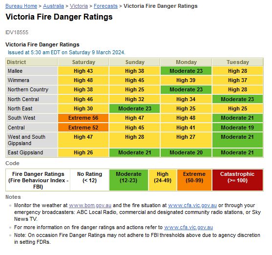
Bushfires, prescribed fire and fire danger are covered in the Core CPG v1.0 in section 5.2 (p.21-22). The monitoring of bushfire conditions should be undertaken regularly and, where practical, updated bushfire condition forecasts, warnings and alerts accessed throughout the activity.
5.2.1 Bushfire trigger points
Trigger points must be based on the fire danger rating.
The risk management plan and emergency management plan should include guidance on trigger points and associated actions for forecasted bushfire danger ratings of very high, severe, extreme and catastrophic, and if a bushfire event occurs.
MORE GUIDANCE
Outdoors Victoria links us to Weather guidance from the Australian Bureau of Meteorology (BOM);
🌦 Weather guide for LAND-BASED ACTIVITIES [PDF]
🌦 Weather guide for MARINE-BASED ACTIVITIES [PDF]
.
SCOUTS VICTORIA
Scouts Victoria has an Extreme Weather and Emergency Management guideline [PDF] Issued: January 20 2020 which has been updated with Interim Extreme Weather and Emergency Management Report (Jan 2023 – Due for update Spring 2024). (Some bad document management there as the older document is the one located via a search).
The purpose of this guideline is to define the processes that should be implemented to ensure the safety and well-being of all Scouts Victoria members, volunteers and employees during extreme weather events and emergencies.
This guideline need you to know if the area your activity is taking place in is a designated ‘Bushfire Prone Area’. To determine if your activity or campsite is in a bushfire prone area, go to https://mapshare.vic.gov.au/vicplan/ and enable Bushfire Prone Areas layer. (Note that areas with a Bushfire Management Overlay are still defined as Bushfire Prone Areas.)
From the Tool Bar > Map
Layers: Bushfire selecting BMO – Bushfire Management Overlay and BPA – Bushfire Prone Area

.
From the Interim Extreme Weather and Emergency Management guideline (Jan-2023);
Cancel, Reschedule or Relocate an Activity
The Leader in Charge of an activity must cancel, reschedule, or relocate a Scouting activity at the earliest opportunity if any of the following occur:
• A fire danger rating of “Catastrophic” is declared for the fire district in which an activity is planned, and the activity is in a designated “Bushfire Prone Area”
• A fire danger rating of “Extreme” is declared for the fire district in which the activity is planned, and the “Fire Danger Rating Trigger Actions” cannot be complied with.
• An “Emergency Warning”, “Watch and Act Warning”, or “Recommendation to Evacuate” is issued for the location of the activity
• A warning is issued against travel to the location of the activity
The Fire Danger Rating Trigger Actions;

.
TOOLS
🚑 Vic Emergency https://www.emergency.vic.gov.au/respond/ (also available as a phone app)
⛈ BOM Weather http://www.bom.gov.au/ (also available as a phone app)
🌩 My Lightning Tracker (phone app)
🌊 Willy Weather (Tides & Wind) https://www.willyweather.com.au/ (also available as a phone app)
FIRE
🔥 CFA – Includes a 4 Day Forecast https://www.cfa.vic.gov.au/

🔥 Victoria Fire Danger Ratings http://www.bom.gov.au/vic/forecasts/fire-danger-ratings.shtml
FLOOD / RIVER HEIGHT
🌊 BOM – Australia Rainfall and River Conditions http://www.bom.gov.au/australia/flood/
.